 www.geodatenkatalog.de (S3F)
Keyword
effektive Durchwurzelungstiefe
81 record(s)
Provided by
Type of resources
Available actions
Topics
Keywords
Contact for the resource
Update frequencies
Service types
-
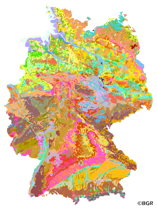
The first country wide soil map at a scale of 1:1,000,000 (BUEK1000) has been compiled on the basis of published soil maps of the former German Democratic Republic and the pre 1990 federal states of Germany. To do this, it was necessary to match the soil systems used in East and West Germany and to develop standardized descriptions of soil units. A relatively homogeneous map has resulted, which permits uniform assessment of the soils throughout Germany. The map shows 71 soil mapping units, described in the legend on the basis of the German and FAO soil systems. Each soil unit has been assigned a characteristic soil profile (Leitprofil) as an aid to map interpretation. For the first time the subdivision of the country into 12 soil regions has been represented on the map. This subdivision was coordinated with the state Geological Surveys. These soil regions will represent the highest hierarchic level of nation wide soil maps in future. The colours of soil units correspond to the standards of the 'Bodenkundliche Kartieranleitung' (KA 3; Guidelines for Soil Mapping). The various hues characterize differences in relief or soil humidity. The BUEK1000 was produced digitally. It is an important part of the spatial database integrated in the Soil Information System currently being established at the Federal Institute for Geosciences and Natural Resources (FISBo BGR). It can be used together with the characteristic soil profiles to derive thematic maps related to nation wide soil protection. The scale of the BUEK1000 makes it especially suitable for small scale evaluations at federal or EU level.
-
Web Map Service (WMS) of the BUEK1000. The first country wide soil map at a scale of 1:1,000,000 (BUEK1000) has been compiled on the basis of published soil maps of the former German Democratic Republic and the pre 1990 federal states of Germany. To do this, it was necessary to match the soil systems used in East and West Germany and to develop standardized descriptions of soil units. A relatively homogeneous map has resulted, which permits uniform assessment of the soils throughout Germany. The map shows 71 soil mapping units, described in the legend on the basis of the German and FAO soil systems. Each soil unit has been assigned a characteristic soil profile (Leitprofil) as an aid to map interpretation. For the first time the subdivision of the country into 12 soil regions has been represented on the map. This subdivision was coordinated with the state Geological Surveys. These soil regions will represent the highest hierarchic level of nation wide soil maps in future. The colours of soil units correspond to the standards of the 'Bodenkundliche Kartieranleitung' (KA 3; Guidelines for Soil Mapping). The various hues characterize differences in relief or soil humidity. The BUEK1000 was produced digitally. It is an important part of the spatial database integrated in the Soil Information System currently being established at the Federal Institute for Geosciences and Natural Resources (FISBo BGR). It can be used together with the characteristic soil profiles to derive thematic maps related to nation wide soil protection. The scale of the BUEK1000 makes it especially suitable for small scale evaluations at federal or EU level.
-
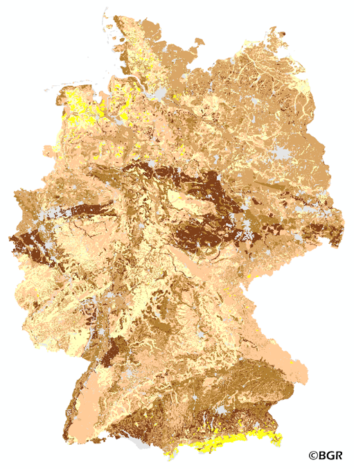
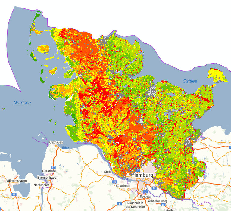
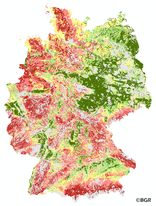
The map of the effective rooting depth gives an overview of the rooting capacity of German soils. The effective rooting depth is the size of the soil reservoir that the plant can reach to get water in years of drought. The effective rooting depth is determined by both crop and soil properties. The rooting depth is derived from profile data of the landuse stratified soil map of Germany at scale 1:1,000,000. The method is taken from Bodenkundliche Kartieranleitung KA4 (1994) and is documented in the Methoden-WIKI of the FISBo BGR. The land use information is derived from the CORINE Land Cover data set (2006).
-
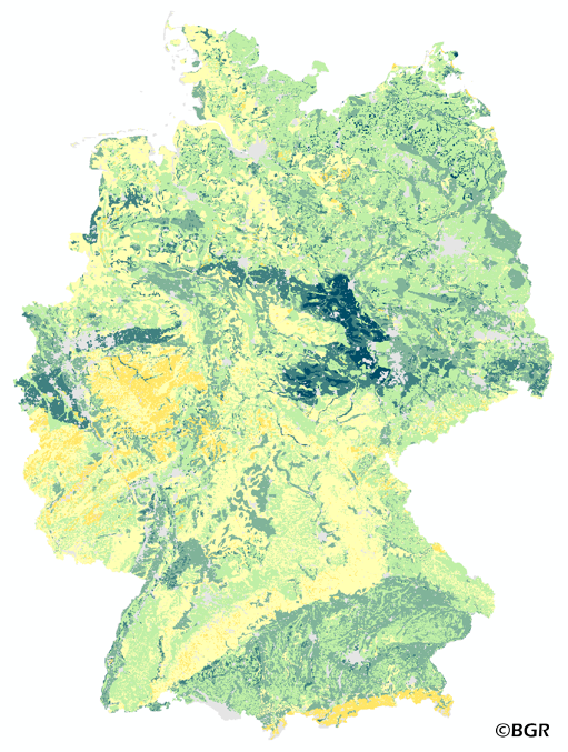
The map of the available water holding capacity in Germany gives an overview of the amount of water in a soil that is normally available for plant growth. The map shows the available water from the surface to effective rooting depth, which is derived from land use and soli data. The method is published in the Bodenkundliche Kartieranleitung KA4 (1994) and in the documentation of Ad-hoc-AG Boden (representing the soil experts of the geological services of the German federal states). The land use information is taken from the CORINE Land Cover data set (2006).
-
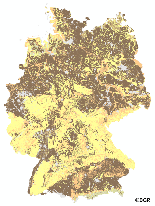
The map of the soil depth gives an overview of the rooting capacity of German soils. The soil depth is derived from profile data of the landuse stratified soil map of Germany at scale 1:1,000,000. The lower limit of a soil is bedrock or a groundwater influenced horizon. The method is derived from Bodenkundliche Kartieranleitung KA5 (2005) and is documented in the MethodenWIKI of the FISBo BGR. The land use information is derived from the CORINE Land Cover data set (2006).
-
The map of the available water holding capacity in Germany gives an overview of the amount of water in a soil that is normally available for plant growth. The map shows the available water from the surface to effective rooting depth, which is derived from land use and soli data. The method is published in the Bodenkundliche Kartieranleitung KA4 (1994) and in the documentation of Ad-hoc-AG Boden (representing the soil experts of the geological services of the German federal states). The land use information is taken from the CORINE Land Cover data set (2006).
-
Auf der Grundlage der nutzungsdifferenzierten Bodenübersichtskarte im Maßstab 1:250.000 wird die Menge an pflanzenverfügbarem Bodenwasser (Wpfl) in 7 Klassen abgebildet. Die Menge an pflanzenverfügbarem Bodenwasser ergibt sich aus Summe von nutzbarer Feldkapazität im effektiven Wurzelraum (nFKWe) und dem Wasser, das den effektiven Wurzelraum durch kapillaren Aufstieg (KA) aus dem Grundwasser erreicht. Die Maßeinheit ist mm. Für die Berechnung des kapillaren Aufstiegs werden Klimadaten der Periode 2001 bis 2020 verwendet. Die Nutzungsdifferenzierung beruht auf CORINE-Land Cover (CLC5_2018). Die dort aufgeführten Landnutzungsklassen wurden zu 5 Klassen (Acker, Grünland, Wald, Ödland und Siedlung/Verkehr) aggregiert. Die Menge an pflanzenverfügbarem Bodenwasser ist von einer Vielzahl von Faktoren abhängig. Dazu zählen die Bodenart, die Lagerungsdichte, der Humusgehalt, und die Nutzung.
-
The exchange frequency of water in soils describes how often water and the dissolved substances in it can be replaced in a soil layer during the annual leachate flow. Small water storage capacity means high replacement frequency. The risk of the discharge of easily detachable materials like nitrate is given at high exchange rates.